Calculate height or line of sight from the other value with unit conversion in meters, centimeters, millimeters, feet, inches, or yards.
Related Calculators
- Antenna Beamwidth Calculator
- Horizon Distance Calculator
- Earth Curve Calculator
- Radio Distance Calculator
- Antenna dBi Range Calculator
- All Physics Calculators
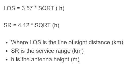
Line of Sight Formula
The line of sight calculator estimates how far an antenna can reach before Earth curvature blocks a direct path. It is commonly used for radio planning, tower placement, marine communication, surveillance systems, and any application where antenna height affects horizon distance.
LOS is the geometric line-of-sight distance in kilometers, SR is the approximate service range in kilometers, and h is the antenna height in meters. The service range value is slightly larger because it is intended as a practical radio-horizon estimate rather than a purely visual horizon estimate.
What the Calculator Tells You
- Line of sight distance shows the approximate direct horizon from an antenna of a given height.
- Service range gives a more practical communication estimate for radio use in clear conditions.
- Height matters most when terrain is flat and obstructions such as buildings, hills, and trees are minimal.
How to Use the Calculator
- Enter the antenna height above the surrounding ground.
- Select the unit that matches your measurement.
- Calculate the corresponding line of sight distance.
- Use the result as a first-pass horizon estimate before doing a full signal or coverage analysis.
Variable Definitions
- LOS = line of sight distance
- SR = service range
- h = antenna height
Imperial Form
If the antenna height is measured in feet and you want the result in miles, these equivalent forms are often convenient:
Example
For an antenna mounted 30 meters above ground:
This means the geometric horizon is about 19.55 km, while the practical radio service estimate is about 22.57 km under favorable conditions.
Quick Reference Table
| Antenna Height | Line of Sight | Service Range |
|---|---|---|
| 2 m | 5.05 km | 5.83 km |
| 10 m | 11.29 km | 13.03 km |
| 30 m | 19.55 km | 22.57 km |
| 100 m | 35.70 km | 41.20 km |
When Both Ends of the Link Are Elevated
If both the transmitter and receiver are above ground, add the horizon contribution from each side to estimate the total direct path.
This is useful for tower-to-tower, building-to-building, shore-to-ship, and repeater planning scenarios.
Important Assumptions
- The formulas assume a clear path to the horizon.
- They do not account for mountains, foliage, buildings, or local terrain clutter.
- They estimate horizon distance, not complete signal quality.
- Frequency, antenna gain, transmit power, receiver sensitivity, and Fresnel zone clearance still affect whether a communication link will actually perform well.
FAQ
- What is line of sight?
- Line of sight is the maximum direct distance an elevated object can “see” to the horizon before Earth curvature blocks the path.
- What is service range?
- Service range is a practical radio-horizon estimate that is slightly larger than pure geometric line of sight and is often more useful for antenna coverage planning.
- Does doubling antenna height double the range?
- No. Distance increases with the square root of height, so range grows more slowly than height. To roughly double the horizon distance, you need about four times the height.
- Can this calculator be used for visual observation and radio links?
- Yes. Use the line of sight value for a conservative visual horizon estimate and the service range value for a basic radio-planning estimate.
- Does this calculator replace a full RF link budget?
- No. It is best used as a fast horizon-distance tool. A full coverage study should also consider path loss, interference, terrain, and equipment performance.